
BackCountry Nav Topo Maps GPS - DEMO
500M + oyuncunun güvendiği Android Oyun Platformu, BlueStacks ile PC'de oynayın.
Sayfa Değiştirilme tarihi: 23 Şubat 2020
Play BackCountry Nav Topo Maps GPS - DEMO on PC
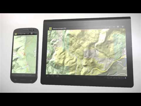
Use offline topo maps and GPS on hike trails without cell service! The GPS in your Android phone can get its position from satellites, and you don’t have to rely on your data plan to get maps. Have more fun and safe GPS adventures in the backcountry.
Preload FREE offline topo maps, aerial photos, and road maps on your storage memory, so they are ready when you need them.
Add custom GPS waypoints in longitude and latitude, UTM or MGRS grid reference. Import GPS waypoints from GPX files. Choose icons for waypoints much like in MapSource. (This app uses the WGS84 datum, NAD27 is available in settings).
Use GPS for hunting a waypoint or geocache, for recording tracks and GPS waypoints on your trip, all the while tracking your quest on topographic maps.
About topo (topographic) maps: Topo maps show terrain through color and contours, and are useful for navigation offroad. Topo maps and GPS can be used for hiking, hunting, kayaking, snowshoeing, & backpacker trails.
The app has many built in map sources and allows you to create your own maps with Mobile Atlas Creator. Built in sources include:
OpenStreetMaps and NASA landsat data worldwide.
OpenCyle Maps are topo maps that show terrain worldwide.
USGS Color Aerial photography.
Topographic Maps of Spain and Italy.
Outdoor maps of Germany and Austria
Topo maps of New Zealand
Here are some of the outdoor GPS activities BackCountry Navigator has been used for:
Hiking both on hiking trails and off trail.
Camping, to find the perfect camping site or the way back to camp.
Hunting trips for hunting wild game in rugged areas, including recon for the hunt.
Bait fishing or fly fishing with a buddy.
Search and Rescue (SAR) with GPS.
Kayak and canoe trips on inland lakes and streams or marine, coastal waters.
Backpacker trips: using topo maps of wilderness areas and national forests to navigate on trails with the GPS.
Snow adventures including snowmobiling, skiing (alpine or cross country) and snowshoeing. Create a memory. Map it out.
This a great addition to the outdoor gear you bought at Cabelas, REI, or another outdoor store. Your android phone could substitute for a Garmin or Magellan outdoor handheld GPS! You storage has memory for maps.
Find your own ways to have fun in the outdoors. Be a maverick by venturing into new territory beyond cell service boundaries. Become a pro at navigation with GPS.
BackCountry Navigator has been previously available on WM devices and preloaded on the Trimble Nomad outdoor rugged device. This Android version is more flexible, featured, and fun.
BackCountry Nav Topo Maps GPS - DEMO oyununu PC'de oyna. Başlamak çok kolay.
-
BlueStacks'i PC'nize İndirin ve Yükleyin
-
Play Store'a erişmek için Google girişi yapın ya da daha sonraya bırakın.
-
Sağ üst köşeye BackCountry Nav Topo Maps GPS - DEMO yazarak arayın.
-
BackCountry Nav Topo Maps GPS - DEMO uygulamasını arama sonuçlarından indirmek için tıklayın.
-
(iEğer Adım 2'yi atladıysanız) BackCountry Nav Topo Maps GPS - DEMO uygulamasını yüklemek için Google'a giriş yapın.
-
Oynatmaya başlatmak için ekrandaki BackCountry Nav Topo Maps GPS - DEMO ikonuna tıklayın.
