
Variometer-Sky Land Tracker
Chơi trên PC với BlueStacks - Nền tảng chơi game Android, được hơn 500 triệu game thủ tin tưởng.
Trang đã được sửa đổi vào: 29 tháng 6, 2019
Play Variometer-Sky Land Tracker on PC
Variometer, Vario, G_Vario, G_Variometer, Tracker (Compatible for GPS only or Phone Baro Sensor or FlyNet2 or BlueFlyVario or GoFly Pico), 3D Track View with 3D terrain maps.
Paragliding, hang gliding and all air sports, Radio Control Plane and skiing, sailing, mountain climbing, etc.
Portal tracker instruments for all Outdoor sports.
Support MOBAC offline map & Self Downloading OSM & Support MapsForge(.map) offline map
Support FAI-CIVL(http://vali.fai-civl.org/supported.html) valid IGC files. (GNSS : http://g-variometer-vali.blogspot.kr)
Flight instruments is expensive, but your phone is also expensive equipment.
Your phone is better than that , you can perform a variety of functions.
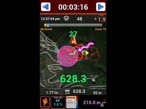
Using Compass & GPS & Pressure Sensor, flight time, speed, altitude, vertical speed, L/D is displayed.
If your phone is equipped with pressure sensor, In air sports mode, variometer functions can be maximized.
Pressure Sensor sensitivity of this filter using the Fourier Transform is better than any other filter using a simple lowpass filter or kalman.
Therefore more precise user setting is possible.
After simple one click, Ready to take off at once, auto-start-stop, manual-start-stop is possible
Big font and high contrast raised the visibility in outdoor.
Through manual built in the app, you can learn easily how to use.
Flight time, battery level, GPS status, and vertical speed, maximum speed, speed, maximum altitude, altitude, Hpa pressure, temperature (varies by altitude), weather (wind direction, wind speed), Task orientation, remaining distance, the total path length, Fuel Gage(for Motor Skysports) are displayed
It displays the direction and intensity of drift and thermal detecting also.
Waypoint and Route creation is easier and faster than any other app.
Waypoint Import Export Support (WPT, CUP format)
Map of the Google, OSM, GoogleV2 is in use.
Track play function is best function same as seeing the actual flight.
Indexing and rewinding and the execution speed can be adjusted.
You can also see in 3D Track(shared track) with 3D terrain maps(shared track).
Seeing track thumbnail, you can easily find a specific flight record and
Your indexing speed can be also fast through altitude graph.
Track files can be sent via email to other users and
In addition, KML, GPX files are saved and automatically converted.
Navigation displays to the users the real-time shortest course from the current location and flight direction to next task, remaining distance, needed altitude against glide ratio
In briefing, share discussion with colleagues easy.
The units (mile, feet, meter, knot, ft / s, m / s, mph, kph, ℃, ℉) can be freely selected.
Coordinate system of the DD-MM-SS.SS, UTM, WGS84, etc can be selected
When performing in background Mode, track can be recorded throughout the day precisely and
During the mode, the sonic variometer functions and task passing, starting height sound alarm can be performed continuously.
The altitude can be set in a variety of ways.
Based Terrain Elevation, sea level air pressure reference, GPS altitude, the user manual setting is possible.
GPS environment will be best in flight, You can get reliable performance.
For feature requests and uncomfortable, please send mail to.
airfoil.hangglider@gmail.com
Chơi Variometer-Sky Land Tracker trên PC. Rất dễ để bắt đầu
-
Tải và cài đặt BlueStacks trên máy của bạn
-
Hoàn tất đăng nhập vào Google để đến PlayStore, hoặc thực hiện sau
-
Tìm Variometer-Sky Land Tracker trên thanh tìm kiếm ở góc phải màn hình
-
Nhấn vào để cài đặt Variometer-Sky Land Tracker trong danh sách kết quả tìm kiếm
-
Hoàn tất đăng nhập Google (nếu bạn chưa làm bước 2) để cài đặt Variometer-Sky Land Tracker
-
Nhấn vào icon Variometer-Sky Land Tracker tại màn hình chính để bắt đầu chơi
