
Planimeter - GPS area measure | land survey on map
商务办公 | vistech.projects
在電腦上使用BlueStacks –受到5億以上的遊戲玩家所信任的Android遊戲平台。
Play Planimeter - GPS area measure | land survey on map on PC
Planimeter is a the best land surveying app and field area measure tool. You can also measure distance, perimeter, bearing, angle and GPS coordinates in different formats on Google Maps. You can save, edit, label, view, share your measurements as KML data files and screenshots.
Check out Free Planimeter Guide with details about how to determine square footage and all other features: http://goo.gl/J7iZIn
Features you won't find in other apps:
- live auto map measure using GPS tracking (walk / drive around boundary) with time interval and accuracy settings;
- magnifying glass for very accurate pin placement for distance and area measure: https://youtu.be/Hha_nmC032M
- add point with exact distance and angle input (Distance and Bearing Feature): http://goo.gl/8XbhJU
- create, share and view KML directly from e-mail attachment , file browser, etc: http://goo.gl/2cdI8w
- intuitive and friendly way to add labels in Notes Mode (extra paid mode): http://goo.gl/s52VdU
- quick share, directions and navigation to selected point is available from Notes Mode (extra paid mode): http://goo.gl/nCRTQi
- smart features to remove redundant points and generate convex areas;
- different geo-coordinate formats;
- quick switch and view measured path and polygons in pre-cached Google Earth app (extra paid feature);
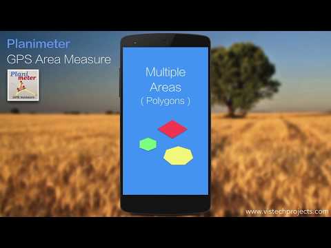
- Multiple areas measurements (in-app purchase): https://goo.gl/SrFMj3
- Circle Mode (in-app purchase) - radius around point https://goo.gl/dkHuvy
- Volume / Cost calculator when height or rate per area unit entered https://goo.gl/dkHuvy
Multilingual: English, Portuguese, Russian, German
The app has many positive comments from users and has been successfully used in different areas:
- outdoor activities: sports, golf (distance between two points or holes), bike tours, trail planning, travelling, quick path measure , map your run
- garden and yard: landscape planning, grass cutting, lawn care and mowing, fencing, grass seeding.
- agriculture, poultry and farming: harvesting, fertilizing, crops (corn, wheat, maize, beet, etc.) planning and estimation, crop fields labeling for the records, field area measure, paddocks and area fencing for cows, horses, chickens, rabbits, etc.
- solar energy: area estimation for solar panels, flat roof area estimation
- construction: land survey, road sealing, parking lot repairing
- forestry: objects and tree mapping, damage area estimation, measure land area
- other: ponds size and are measure; pole lines planning; directions and navigation to the marked / shared point; movement tracking; get exact GPS coordinates of way-points; fence calculation; measure distance on google map, geocaching.
More about the app, tips and updates: https://vistechprojects.blogspot.com/search/label/Planimeter
Check out Free Planimeter Guide with details about how to determine square footage and all other features: http://goo.gl/J7iZIn
Features you won't find in other apps:
- live auto map measure using GPS tracking (walk / drive around boundary) with time interval and accuracy settings;
- magnifying glass for very accurate pin placement for distance and area measure: https://youtu.be/Hha_nmC032M
- add point with exact distance and angle input (Distance and Bearing Feature): http://goo.gl/8XbhJU
- create, share and view KML directly from e-mail attachment , file browser, etc: http://goo.gl/2cdI8w
- intuitive and friendly way to add labels in Notes Mode (extra paid mode): http://goo.gl/s52VdU
- quick share, directions and navigation to selected point is available from Notes Mode (extra paid mode): http://goo.gl/nCRTQi
- smart features to remove redundant points and generate convex areas;
- different geo-coordinate formats;
- quick switch and view measured path and polygons in pre-cached Google Earth app (extra paid feature);
- Multiple areas measurements (in-app purchase): https://goo.gl/SrFMj3
- Circle Mode (in-app purchase) - radius around point https://goo.gl/dkHuvy
- Volume / Cost calculator when height or rate per area unit entered https://goo.gl/dkHuvy
Multilingual: English, Portuguese, Russian, German
The app has many positive comments from users and has been successfully used in different areas:
- outdoor activities: sports, golf (distance between two points or holes), bike tours, trail planning, travelling, quick path measure , map your run
- garden and yard: landscape planning, grass cutting, lawn care and mowing, fencing, grass seeding.
- agriculture, poultry and farming: harvesting, fertilizing, crops (corn, wheat, maize, beet, etc.) planning and estimation, crop fields labeling for the records, field area measure, paddocks and area fencing for cows, horses, chickens, rabbits, etc.
- solar energy: area estimation for solar panels, flat roof area estimation
- construction: land survey, road sealing, parking lot repairing
- forestry: objects and tree mapping, damage area estimation, measure land area
- other: ponds size and are measure; pole lines planning; directions and navigation to the marked / shared point; movement tracking; get exact GPS coordinates of way-points; fence calculation; measure distance on google map, geocaching.
More about the app, tips and updates: https://vistechprojects.blogspot.com/search/label/Planimeter
在電腦上遊玩Planimeter - GPS area measure | land survey on map . 輕易上手.
-
在您的電腦上下載並安裝BlueStacks
-
完成Google登入後即可訪問Play商店,或等你需要訪問Play商店十再登入
-
在右上角的搜索欄中尋找 Planimeter - GPS area measure | land survey on map
-
點擊以從搜索結果中安裝 Planimeter - GPS area measure | land survey on map
-
完成Google登入(如果您跳過了步驟2),以安裝 Planimeter - GPS area measure | land survey on map
-
在首頁畫面中點擊 Planimeter - GPS area measure | land survey on map 圖標來啟動遊戲
